In a campaign that sought to promote the environmental quality of the country and publicize the imposing natural beauty of the country, people chose the most wonderful places in the Argentine geography.
The Salinas Grandes de Jujuy, the Perito Moreno Glacier of Santa Cruz, the Talampaya and Nahuel Huapi National Parks, the Missionary Jungle, the Mina Clavero River and the La Estrella Bathing are the Natural landscapes of Argentina, These are the destinations chosen by tourists:
Salinas Grandes (Jujuy)
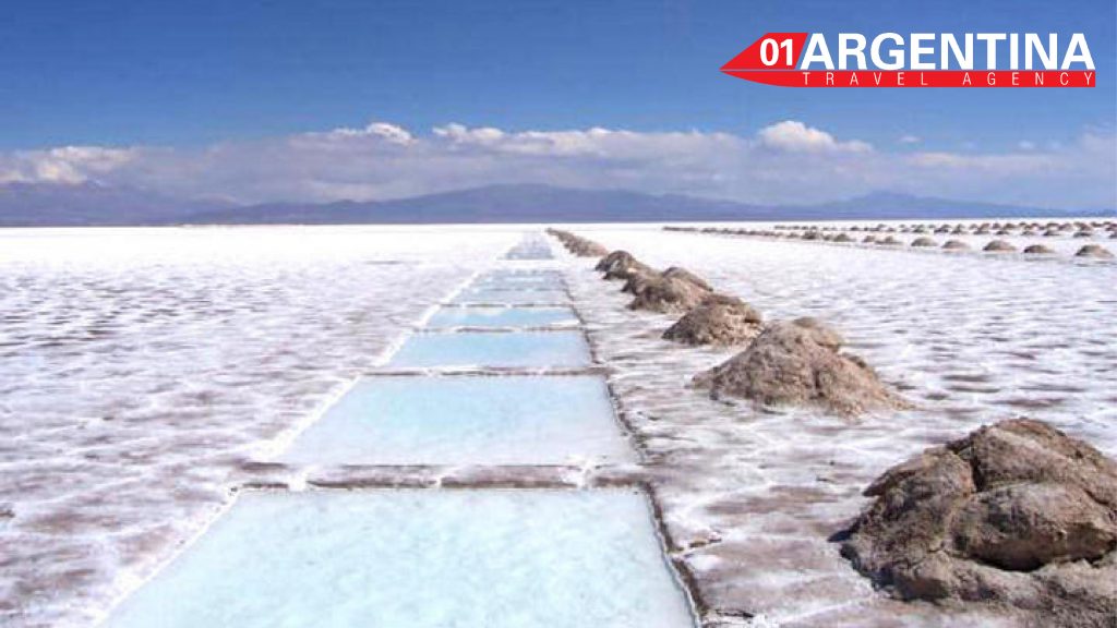
With its crystal white, it is the third largest salt flat in South America with an extension greater than 12 thousand hectares to heaven. It has the name of “great” because it is the third largest salt flat in South America with an area greater than 12 thousand hectares in the open. One of the whitest areas that can be found in Argentina and with a texture of robust hardness that will be necessary to appreciate closely to understand.
Located about 190 kilometers from the provincial capital, the Salinas Grandes capture the attention of visitors of all ages and arouse great creativity by having a camera in hand. An immense depression totally depopulated that becomes even more attractive if a few hours before it rained. Where only artisans who work salt reside and offer delicately carved objects with spikes and axes.
Although access is relatively easy, going uphill and winding up to over 4,100 meters, there are also numerous agencies that offer the route in Jujuy – also in the neighboring province of Salta. In case of doing it in a particular way, it is important to load enough fuel, bring food, although in the area there is a restaurant, sunglasses to protect the view and light shoes to splash in this real show.
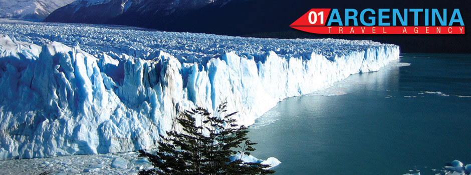
Perito Moreno Glacier and the Glaciers National Park
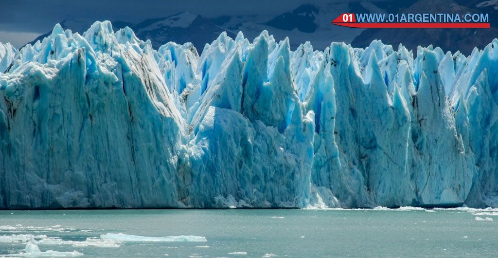
There is no doubt: the Perito Moreno Glacier, located in the Province of Santa Cruz, is one of the most impressive natural landscapes in Argentina. It is a spectacular ice mole with blue cavities and thunderous breaks, which extends from the Andes to Lake Argentino, facing the Magallanes peninsula. It is part of the spectacular Los Glaciares National Park and is about 80 kms. from El Calafate. The glacier is one of the 49 ice tongues that form, feed and maintain the Patagonian Ice Field, a huge mass of almost 17,000 square kilometers, 900 meters thick and where it snows 350 days a year.
The Perito Moreno shows a phenomenon that provides him with a source of spectacularity: his ice progresses incessantly, which gives rise to the rupture and detachment of gigantic blocks of ice on his forehead 5 km wide, which has given him world famous and is a source of baptism of the Canal de los Témpanos; place where ice fragments of epic proportions navigate. Surrounded by the purest nature, the glacier is considered one of the greatest natural wonders in the world and its simple existence is a gift for those who know it. Every few minutes fall from this glacier (which exceeds 60 meters above the water) pieces of various sizes and many tons, producing a stridency comparable to the sound of thunder.
Iguazu Falls and the Missionary Jungle
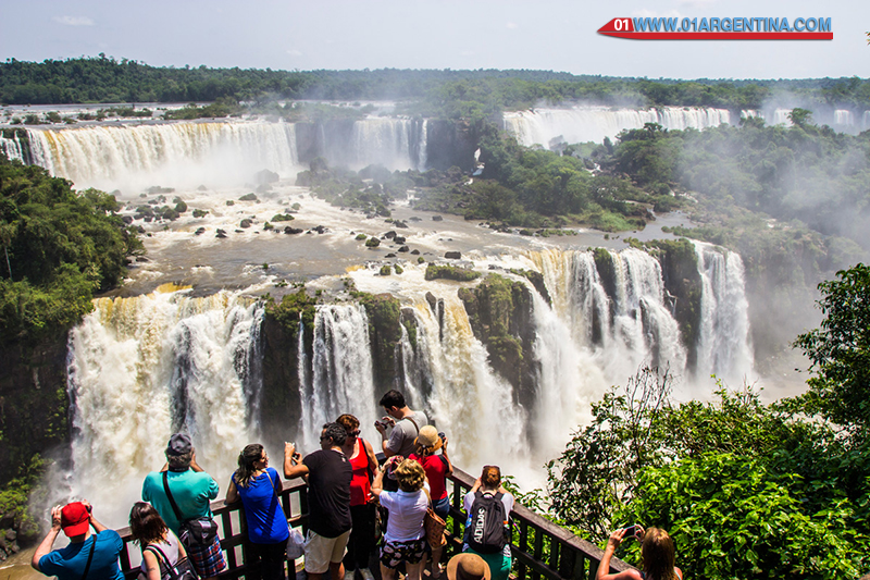
The magnificent Iguazu Falls, one of the Seven Wonders of the World, are made up of 275 waterfalls that fall from the most diverse heights. The highest, 80 meters, is known as the Devil’s Throat.
An incomparable plant context frames one of the most opulent natural landscapes in the world: the Iguazu Falls. It is more than 2 km of waterfalls that exceed 70 meters high, a spectacular manifestation of one of the increasingly scarce resources on the planet: water.
Valleys, rivers, lush subtropical vegetation and even mountain ranges, which reach 800 m high, shape a rainy and humid forest that occupies more than 35% of the missionary territory.
On an area of about 29,800 km2, the Missionary Forest offers a harmonious combination of valleys, rivers, lush subtropical vegetation and even mountain ranges that reach 800 m high, giving way to a rainy and humid forest that occupies more than 35% of the missionary territory. It is part of the Atlantic Forest, an ecoregion that extends from the Serra do Mar on the Brazilian coast, to eastern Paraguay and almost the entire province of Misiones. It is also one of the most threatened natural areas in the world due to continuous clearing. Home of the yaguareté and tatú-carreta, more than 400 species of birds coexist in its space that flood the foliage of giant trees.
On the other hand, the Missionary Forest has the Yerba Mate Route since it is here that this emblematic plant of the Argentine culture is cultivated almost exclusively. It is an important source of economic resources for farmers who grow it in considerable areas to meet the regional demand for this product, and there is also a highly developed industry related to its manufacturing and packaging processes. From a tourist perspective, almost all of the tourist flow that arrives in Misiones has the Jungle as its main attraction since there are inserted the most important destinations and attractions of the province of Misiones such as Iguazu Falls with 1,500,000 visitors per year, the Moconá Falls and the more than 500 jumps scattered throughout the missionary geography.
Talampaya National Park
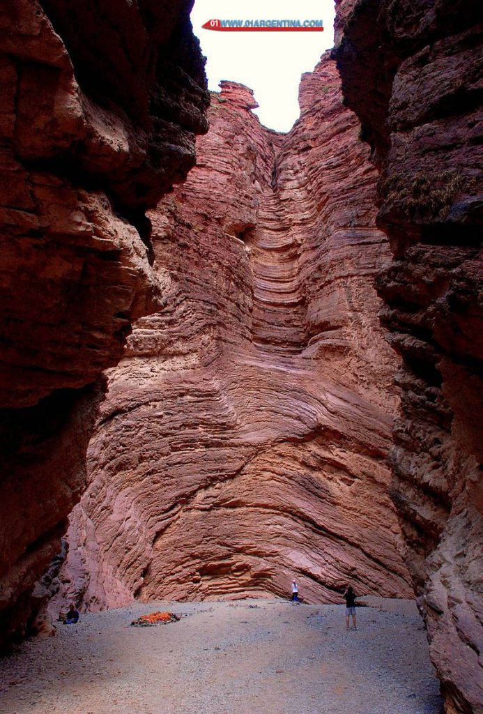
In the center of the country, La Rioja offers the possibility of entering a Triassic stage by visiting the Talampaya National Park and its emblematic circuits that run from its two service areas: Rainbow Canyon and Talampaya Canyon. It is crossed by National Route No. 76 that connects the towns of West Rioja with the City of Patquia of the same province. This route was born at the intersection of Baldecitos at its intersection with National Route No. 150, the southern end of the protected area, and continues to the town of Villa Unión, the main tourist services center in the region.
The visit to this World Heritage Site, recognized as such in the year 2000 by UNESCO, transports us in time on a fantastic trip to the Triassic. The unusual formations of this national park, with the Talampaya River Canyon as the main axis, house a set of fossils corresponding to the Triassic period, initiated 245 million years before our era. The vestiges of dinosaurs and plants allow us to experience an initial approach to the evolution of these species and their geological environment.
There is a wide range of guided excursions through different circuits of the park, both in specially prepared vehicles, by bicycle and on foot. These crossings have different options in their rates and there is a daily promotional admission service to the Canyon area, which must be previously coordinated. There are also walks around Villa Unión to learn about the particular idiosyncrasy of the rural inhabitants.
Mina Clavero River
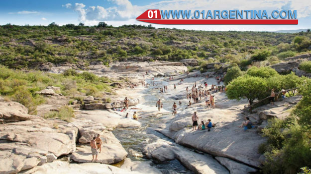
The Mina Clavero River is one of the most beautiful attractions in the city and throughout the Traslasierra Valley, in the province of Córdoba.
In the territory of the Traslasierra Valley, the Mina Clavero River prevails. Its nascent in the Pampa de Achala is the product of the confluence of streams and streams that make it fresh, crystalline and torrential. And the Birth of the river, approximately 30 km from the city of Mina Clavero, is an imposing attraction with a spectacular 102-meter waterfall that represents all the power of nature at its best, the foam of water hitting against stones; the trail with ravines, the condors planning.
Its cold waters, mineralized thanks to the rock corridor, are reputed to be healing. Run from east to west, saving the slope of the mountains by steep slopes and waterfalls, to be encased in lost valleys with beaches only invaded by birdsong. It is one of the most beautiful areas of the province of Córdoba that, in part, reminds of the Andean scenery. “This place has become a mandatory stop for travelers and tourists who wish to know the origin of so many beautiful spas,” says the Córdoba Tourism Agency. “And it is precisely the spas of the Mina Clavero River that have collaborated so that it is nominated among the best natural wonders of Argentina, enjoyed by thousands and thousands of tourists every summer.”
Nahuel Huapi National Park
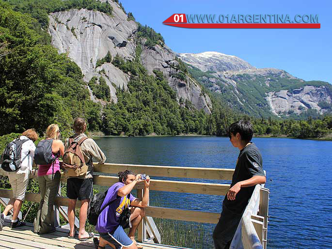
Wet and cold forests, eternal snow on its most iconic hills and a wide variety of lakes, streams and rivers make up an exceptional landscape, admired throughout the world.
Shared by the Patagonia provinces of Neuquén and Río Negro, it is the oldest national park in the country. Wet and cold forests, eternal snow on its most iconic hills and a wide variety of lakes, streams and rivers make up an exceptional landscape, admired throughout the world. On the banks of the lake that gives it its name, the cities of San Carlos de Bariloche and Villa La Angostura, famous international ski centers are located. Hundreds of mammals, birds, native trees and unique fish populate every corner of the famous park.
With San Carlos de Bariloche as the main core of the services, this national park has the largest number of tourist services in the entire system. Nautical excursions in a historic boat that sails the lake 80 years ago, group walks through the ancient Andean forests and the extraordinary dimension of the mountain ranges that frame each of the basins make possible different approaches to the autumn experience.
In 1903 the Expert Francisco Moreno donated the lands that would give rise to the first National Park of Argentina, which in 1922 was declared a National Park of the South. Finally, in 1934 the National Congress sanctioned the Law of creation of the current National Park Nahuel Huapi The Civic Center of Bariloche and the tourist villages of the rest of the park (Mascardi, La Angostura and Traful) facilitate the visitor’s approach to the history of tourism in the area.
Bathed The Star (Formosa)
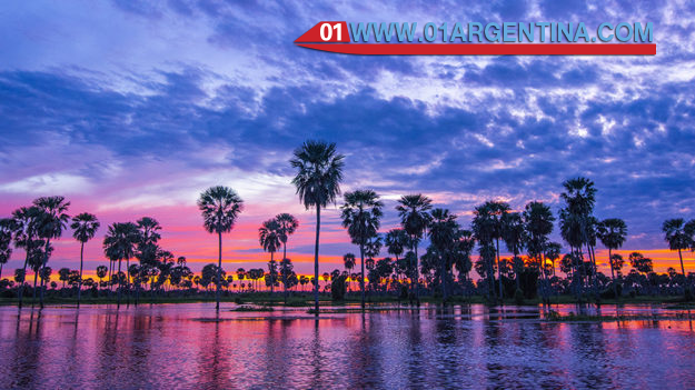
The 400,000 hectares (300 kilometers long and 10 to 20 km wide) of the Bañado make it the third in terms of surface in the Southern Cone, after El Pantanal (Brazil) and the Esteros del Iberá.
Located in Formosa, it is the third largest wetland in South America and has an extensive variety of species in relation to the flora and fauna that make up the place, an offer to get out of the routine. Its aquatic landscape is born by the overflows of the Pilcomayo River that usually occur between January and March, when the water reaches its maximum flow due to the influence of the Andean rains. El Bañado is a unique destination, as it lends itself to being traveled both by land and by water. To navigate it, the best time is from April to September, while the period of greatest drought is usually from October to December, which allows you to tour the place with vehicles, on horseback, or on foot.
One of the most attractive experiences is the wetland route in canoes or canoes, accompanied by local boatmen, they are calm navigations that allow visitors to make sightings of all species and landscapes, which give unparalleled images. In the vicinity of the Bañado La Estrella, communities like Pilagá de Campo del Cielo (to know the crafts made with leaves of carandillo, a kind of palm tree), other communities that inhabit the area are Qom, Wichi and Chulupí, which offer their different activities , creations and languages.