
Buenos Aires to Patagonia Tours tips and advises to travel safe: That Fabled Land of endless, empty open space at the end of the world has humbled THE MOST INTREPID EXPLORERS. Many have described it as a cruel and lonely windswept land unfit for humans. Darwin called Patagonia “wretched and useless”, “yet he was deeply moved by its desolation and forever attracted to it. Today, the 800,000 sq Km (308,000 sq mi) that are Argentine Patagonia continue to challenge and fascinate explorers, mountaineers, nature lovers, sports enthusiasts, and curious visitors from around the world.
From the Río Colorado (Colorado River) in the north to Cape Horn, 2,000 Km (1,200 mi) south, this vast territory may seem monotonously devoid of life uninhabited and inhospitable but these very characteristics make it one of the most amazing natural preserves on earth. Because the population in Patagonia is small relative to its land mass, a staggering variety of plants and wildlife exists in pristine habitats, from the Andes to the great plains and deserts to the coast.
Patagonia has vast stretches of brush desert, lush mountainous areas, and artificially greened areas from water channeling systems such as those used in the Chubut Valley around Gaiman. Micro-weather systems are scattered about, such as the one around the dry hills of the petrified forest of Sarmiento, where the wind can blow up to 220 Kph (136 mph).
The fossil-rich cliffs along the banks of the Río Negro, the pine forests of the Andes, and Tierra del Fuego are some of the more dramatic settings. The trout-rich lakes of Tierra del Fuego and the northern Lake District, from Lago Alumine in the north to Lago Amutui Quimei in the south, provide more relaxing settings.
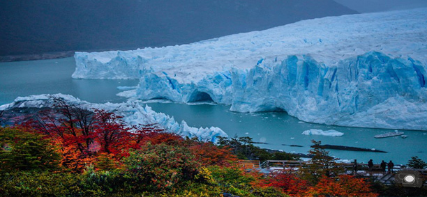
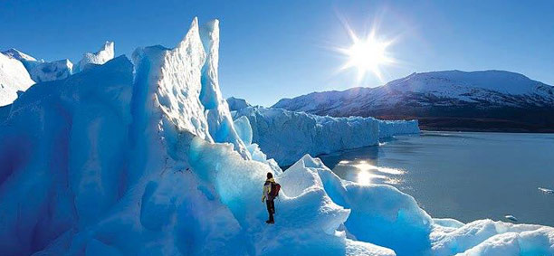
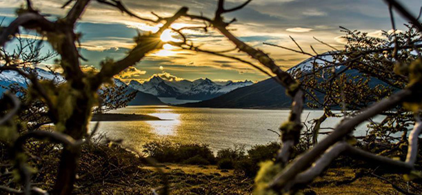
The snow-clad Andean peaks on the western border with Chile form a natural barrier to Pacific storms. The runoff from their eternal snows pours into lakes and streams, eventually spilling into major rivers that wind their way for hundreds of miles across the great arid plateau, until finally flowing into the Atlantic. Farther south, the continental ice cap spreads over 13,500 sq Km (8,400 sq mi), forming the only glacier (Perito Moreno) in the world that is still growing after 30,000 years.
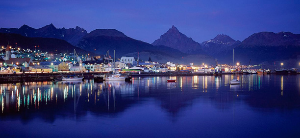
Ushuaia, on the Canal de Beagle (Beagle Channel) in Tierra del Fuego, prides itself on being the southernmost city in the world. Puerto Madryn, on the Atlantic coast in the province of Chubut, is the gateway to the Península Valdés and its unending show of marine life. San carlos de Bariloche, at the foot of the Andes in the northern Lake District, is by far the largest and most frequently visited city in Patagonia and is undeniably picturesque. Yet its beauty lies outside the city limits on a mountain road, by a lake or stream, in the forest, and on top of the surrounding mountains.
El Calafate is located 300 Km (186 mi) north of Río Gallegos via R 5, 253 Km (157 mi) east of Río Turbio on Chilean border via R 40, 213 Km (123 mi) south of El Chaltén via R 40.
Founded in 1927 as a frontier town, El Calafate is the base for all excursions to the Parque Nacional Los Glaciares (Glaciers National Park), which was created in 1937. Because of its location on the southern shore of Lago Argentino, the town enjoys a microclimate much milder than the rest of southern Patagonia. During the long summer days between December and February (when the sun sets around 10 PM), thousands of visitors come to see the glaciers and fill the hotels and restaurants (be sure to make reservation well in advance if you plan on coming during this time).
Getting here may seem like a daunting task, but the experience of seeing the glaciers more than compensates for any difficulties you may encounter. Every year airlines and tour companies are making it easier. From Río Gallegos, the trip can take up to six hours by land across desolate plains filled with more sheep than you can count in a lifetime of sleepless nights. But the journey is occasionally enlivened by the sight of ñanú (rheas), llama-like guanacos, silver gray foxes, and fleet footed hares the size of small deer.
In Avenida del Libertador San Martin (known as Libertador San Martín) there are shops selling sportswear, camping and fishing equipment, souvenirs, and food.
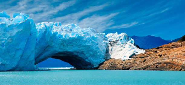
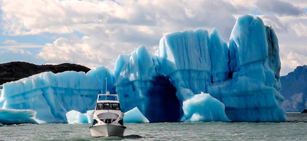
Approximately 1.5 million acres of the Hielo Continental (Continental Ice Cap), which spreads its icy mantle from the Pacific Ocean across Chile and the Andes Argentina and covers area of approximately 21,700 sq Km (8,400 sq mi), are contained in the Parque Nacional Los Glaciares, a UNESCO World Heritage Site. Extending along the Chilean border for 350 Km (217 mi), the park is 40 % covered with ice fields that branch off into 47 major glaciers that feed two lakes, the 15,000 year old Lago Argentino (Argentine Lake, the largest body of water in Argentina) in the southern end of the park and Lago Vietma at the northern and near Monte Fitzroy (Fitzroy Mountain Range), which rises 11,138 ft. Visits to the park are usually by tour, though you could rent a car and go on your own. Travel agents in El Calafate or Buenos Aires can book tours if you haven´t made arrangements from home. Plan on a minimum of three days to see the glaciers and enjoy the town more if you plan to visit El Chaltén, Cueva de las Manos (Cave of the Hands), or any of the lakes.
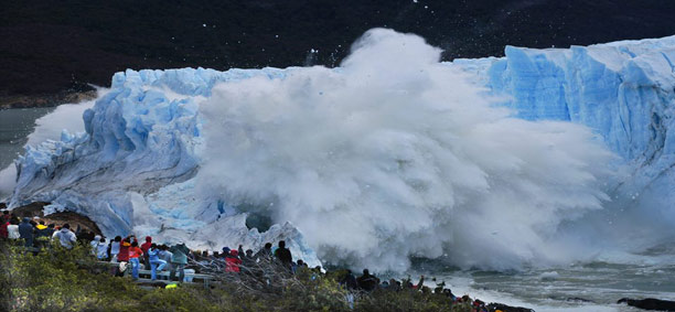
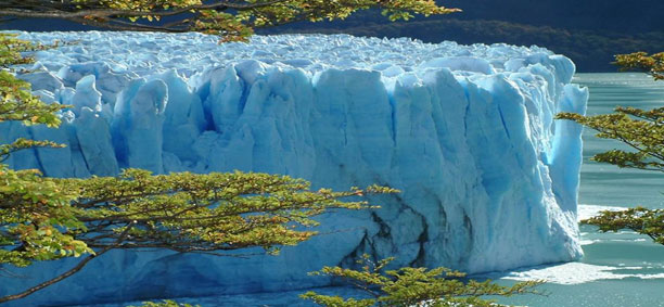
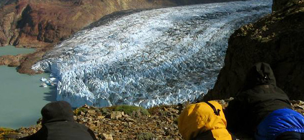
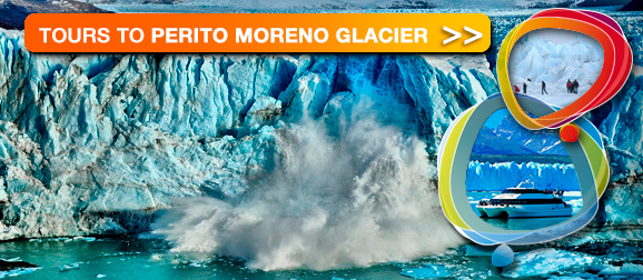
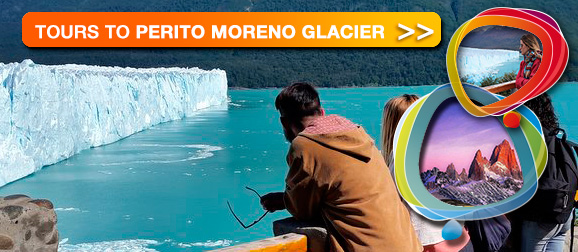
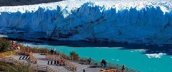
One of the few glaciers in the world still growing after 3,000 years, the Glaciar Moreno (Moreno Glacier), 80 Km (50 mi) and a two hours drive on R 11 from El Calafate, is generally the first destination in the national park. After entering the park, the road winds through hills, until suddenly the starling sight of the glacier, descending like a long white tongue for 80 Km (50 mi) through distant mountains abruptly ends in a translucent blue wall, 3 Km (2 mi) wide and 165 ft high. A viewing area, wrapped around the point of the Península Magallanes, allows you to wander back and forth, looking across the Canal de los Tempanos (Iceberg Channel). Here you listen and wait for the cracking sound- when tons of ice break away and fall with a thunderous crash into Lago Argentino- nature’s number one ice show. Sometimes water even splashes onlookers across the channel! As the glacier creeps across this narrow channel and meets the land on the other side, an ice dam builds up between Brazo Rico on the left and the rest of the lake on the right. As the pressure on the dam increases, everyone waits for the day it will rupture. The last time was in 1986, when the whole thing collapsed in a thunderous finale that lasted hors and could be heard in El Calafate. Videos of this event are still sold locally.
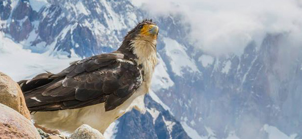
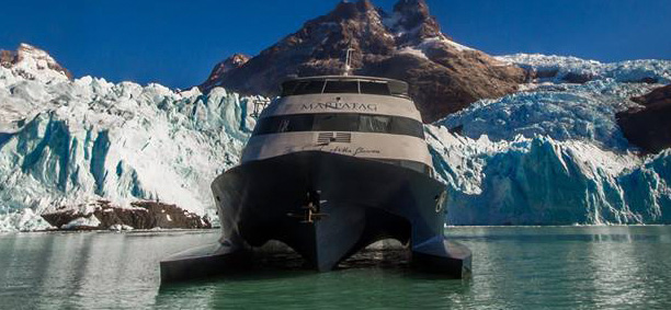
Glaciar Upsala (Upsala Glacier), the largest glacier in South America, is 60 Km (37 mi) long and 10 Km (6 Mi) wide. Accessible only by boat, daily cruises depart from Puerto Banderas (4 Km west of El Calafate via R 11) for 2 ½ hours trip. Along the way, the boats dodge floating islands up from the aqua-green water of Lago Argentino. The seven glaciers that feed the lake deposit their debris into the runoff, causing the water to cloud with minerals ground to fine powder by the glacier’s moraine (the accumulation of earth and stones left by the glacier). Condors and black-chaste buzzard eagles build their nests in the rocky cliffs above the lake. When the boat stops for lunch at Onelli Bay, you can walk behind the restaurant into a wild landscape of small glaciers and milky rivers carrying chunk of ice from four glaciers into Lago Onelli (Onelli Lake).
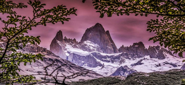
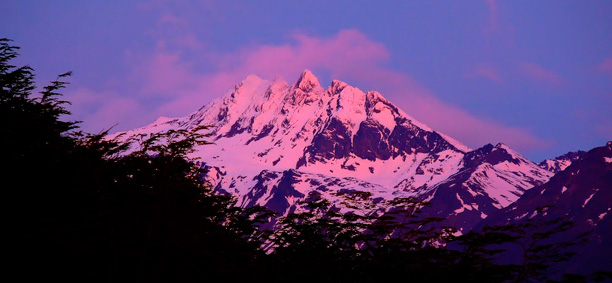
For a jaw-dropping view of the Glaciar Viedma (Viedma Glacier) and Monte Fitzroy, drive north 213 Km (123 mi) to the northern limits of the park. The Fitzroy range is visible for hundreds of miles (weather permitting); the Tehuelche called it Chaltén (Mountains of smoke), which is the name of the village of Chaltén, a hiking mecca, at the base of the range. From this little town, founded in 1985, you can do many great hikes to lakes, glaciers, and stunning viewpoints. Expert mountaineers from every corner of the globe come to Chaltén to plan their ascent of Cerro Torre, that most illusive peak; sometimes they camp for weeks (even months) at laguna Torre, waiting for the wind to die down, the rain to stop, or the clouds to disperse so that they can climb.
Ushuaia is located 230 Km (143 mi) south of Río Grande, 569 Km (370 mi) south Río Gallegos, 914 Km (567 mi) south of El Calafate, 3,580 Km (2,212 mi) south of Buenos Aires.
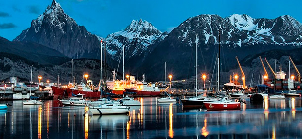
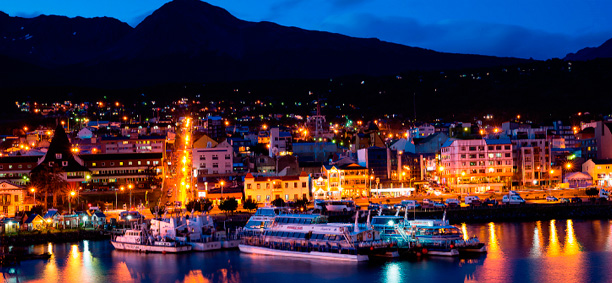
Ushuaia, which at 55 degrees latitude south is closer to the South Pole (2,480 mi) than to Argentina’s northern border with Bolivia (2,540 mi), is the capital and tourism base for Tierra del Fuego, an island at the southernmost tip of Argentina. Although its physical beauty is tough to match, Tierra del Fuego’s historical allure is based more on its mythic past than on reality. The island was inhabited for 6,000 years by Yamana. Haush, Selk´nam, and Alakaluf Indians. But in the late 19th century, after vanquishing the Indians in northern Patagonia, the Argentine Republic was eager to populate Patagonia to bolser its territorial claims in the face of European and Chilean territorial ambitions. An Anglican mission had already been established in Ushuaia in 1871, and Argentina had seen Great Britain claim the Flaklands, a natural Argentine territory. Thus, in 1902 Argentina moved to initiate an Ushuaian penal colony, establishing the permanent settlement of its most southern territories and, by implication, everything in between.
At first, only political prisoners were sent to Ushuaia. But later, fearful of losing Tierra del Fuego to its rivals, the Argentine state sent increased numbers of more dangerous criminals. When the prison closed in 1947, Ushuaia had a population of about 3,000 mainly former inmates and prison staff. Another population boom occurred after Argentina´s 1978 industrial incentives law, which attracted electronics manufacturers like Philco and Groundig to Ushuaia. In recent years many of these television and home-appliance factories have shut down because they weren’t able to compete in the global marketplace. But the children those boom times produced now Ushuaia´s streets.
Today the Indians of Darwin’s “missing link” theory are long gone wiped out by disease and indifference brought by settlers and 45,000 residents of Ushuaia are hitching their star to tourism. Ushuaia feels a bit like a frontier boom town, with noisy, smelly, circa 1970´s cars clogging the streets, and restaurants and hotels opening on once empty lots. In the late 90´s the local government completed an airport that has the capacity to handle direct flights from abroad and finished a deep water pier that welcomes cruise ships stopping for provisions in Ushuaia on their way to the Antarctic. The R 3, the last stretch of the Panamerican Highway, which connects Alaska to Tierra del Fuego, is finally paved.
The town of Ushuaia itself can be called picturesque at best. Parts of it resemble an oversize mining camp a waiting the next strike. Wooden shacks, precariously mounted on upright piers and ready for speedy displacement to a different site, look like entrants in a contest for most original log cabin. A chaotic and contradictory urban landscape includes a handful of luxury hotels amid some of the world’s most unusual public housing projects one monstrous, corrugated tin development has a highway running right through it. Town planning has never been a strong point in Ushuaia; instead, irregular rows of homes sprout with the haphazardness of mushrooms in a moist field.
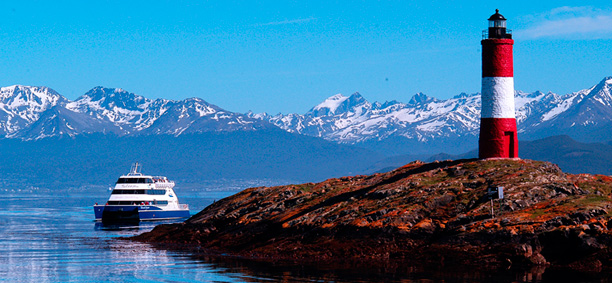
And yet, as you stand on the banks of the Canal de Beagle (Beagle Channel) near Ushuaia, as Captain Robert Fitzroy, the captain who was sent by the English government in 1832 to survey Patagonia, including Tierra del Fuego, must have done so long ago, the spirit of the farthest corner of the world takes hold. What stands out is the light: At sundown it casts the landscape in a subdued, sensual tone; everything feels closer, softer, and more human in dimension despite the vastness of the setting. The snowcapped mountains of Chile reflect the illumination of the setting sun back onto a stream rolling into the channel, as nearby peaks echo their image, on a windless day in the still waters.
Above the city, the last mountains of the Andean Cordillera rise, and just south and west of Ushuaia they finally vanish into the often stormy sea. Snow dots the peaks with white well into summer. Nature is the principal attraction here, with trekking, fishing, horseback riding, and sailing among the most rewarding activities, especially in the Parque Nacional Tierra del Fuego (Tierra del Fuego National Park). In winter, the adventurous have the place to themselves for cross-country and downhill skiing, dog sledding, and snowmobiling across the powdery dunes. In an effort to attract more tourists in winter (presently summer is the busiest season), the government built a new ski resort, Cerro Castor, and began actively promoting winter sports.
The Antigua Casa Beben (Old Beben House) built in 1913, is one of Ushuaia´s original house. It was initially a branch office of Banco Nacion, and then a house owned by the Croatian Beben family, and was finally moved to its current location and restored in 1994. It’s now a cultural center where art exhibitions are mounted.
Rainy days are reality in Ushuaia, but two museums give you an avenue for urban exploration and glimpse into Tierra del Fuego´s fascinating past. Part of the original penal colony, the Presidio was built to house political prisoners, street orphans, and a variety of others social undesirables from the north. Today it house the Museo Marítimo ( Maritime Museum), within Ushuaia´s naval base, with exhibit on the town’s extinct indigenous population, Tierra del Fuego´s navigational past, Antarctic explorations, and life and times in an Argentine penitentiary. You can enter cell block and read the fascinating stories of the prisoners who lived in them while gazing upon their eerily lifelike effigies.
At the Museo del Fin del Mundo (End of the World Museum), you can see a scary large stuffed condor, among other native birds, indigenous items, maritime instruments, and such seafaring related artifacts as an impressive mermaid figurehead taken from the bowsprit of a galleon.
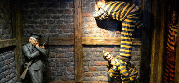
In addition, there are photographs and histories of El Presidio’s original inmates, such as Simon Radowinzky, a Russian immigrant anarchist who received a life sentence for killing an Argentine police colonel. The museum also has the best existing library and bookstore devoted to Tierra del Fuego as well as a snack bar.
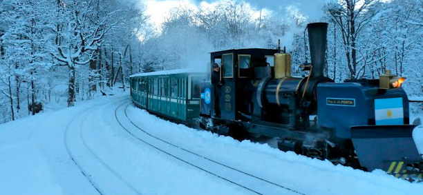
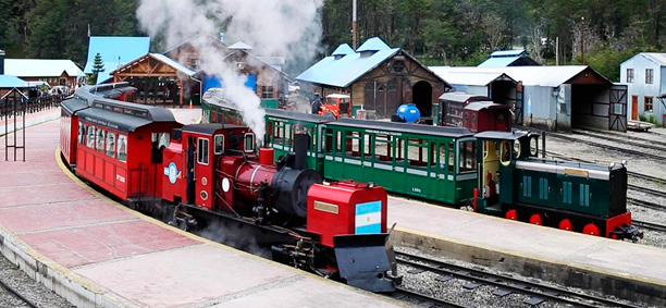
The Tren del Fin del Mundo (Train of the end of the World) takes you to the Parque Nacional Tierra del Fuego, 12 Km (7 ½ mi) away. The train ride is a simulation of the trip on which El Presidio prisoners were taken into the forest to chop wood.
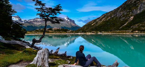
One good excursion in the area is to picturesque Lago Escondido (Hidden Lake) and Lago Fagnano (Fagnano Lake). On the way you pass through deciduous beech-wood forest and past beaver’s dams, peat bogs, and glaciers.
The lakes have campsites and fishing and are good spots for a picnic or a hike. A rougher, more unconventional tour of the lake area goes to Monte Olivia (Mt. Olivia), the tallest mountain along the Canal de Beagle, rising 4,455 ft above sea level. You also pass the Five Brothers Mountains and go through the Garibaldi Pass, which begins at the Rancho Hambre, climbs into the mountain range, and ends with a spectacular view of Lago Escondido. From here you continue on to Lago Fagnano through picturesque countryside past sawmills and lumberyards. To do this trip in a four-wheel-drive vehicle with an excellent bilingual guide.
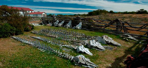
Estancia Harberton ( Harberton Ranch) consist of 50,000 acres of coastal marshland and wooded hillsides. The property was a late 19th century gift from the Argentine government to Reverend Thomas Bridges, officially considered the Father of Tierra del Fuego. Today the ranch is managed by Bridge’s great grandson, Thomas Goodall, and his American wife, Natalie, a scientist who has cooperated with the National Geographic Society on conservation projects; most people visit as part of organized tours, but you’ll be welcome if you stray tea in their home, the oldest building on the island. For safety reasons, exploration of the ranch can only be done through a guide. Lodging is not available, but you can arrange to dine at the ranch by calling ahead for a reservation.
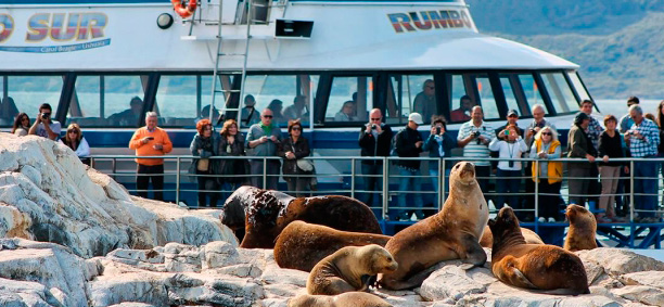
Most tours reach the estancia by boat, offering a rare opportunity to explore the Isla Martillo penguin colony, in addition to a sea lion refuge on Isla de los Lobos ( Island of the Wolves) along the way.
If you’ve never butted heads with a glacier, the mountain range just above Ushuaia is home to the Glaciar Martial. Named after French man Luis F. Martial, a 19th century scientist who wandered this way aboard the warship Romanche to observe the passing of planet Venus, the glacier is reached via a panoramic ski lift. Take the Camino al Glaciar (Glacier road) 7 Km (4 mi) out of town until you reach the Glaciar Martial ski lodge. A 15 minutes ski line ride brings you to the beginning of a 1 Km (½ mi) trail that winds its way over lichen and shale straight up into the mountain. After a strenuous 30 minutes hike, you can cool your heels in one of the many gurgling, icy rivulets that cascade down water worn shale shoots, or enjoy a picnic while you wait for an early sunset. When the sun drops behind the glacier’s jagged crown of peaks, brilliant rays beam over the mountain’s crest, spilling a halo of gold flecked light on the glacier, valley, and channel below. Moments like these are why this land is so magical. However, temperatures drop dramatically after sunset, so come prepared with warm clothing.
The pristine Parque Nacional Tierra del Fuego, 12 Km (7 ½ mi) west of Ushuaia, offers you a change to wander through peat bogs, stumble upon hidden lakes, trek through native canelo, lenga, and wild cherry forests, and experience the wonders of Tierra del Fuego´s rich flora and fauna. Visits to the park, tucked up against the Chilean border, are commonly arranged through tour companies. Trips range from bus tours to horseback riding to more adventurous excursions, such as canoe trips across Lapataia Bay. Another way to get to the park is to take the Tren del Fin del Mundo. One more option is to drive to the park on R 3 (take it until it ends and you see the last sign on the Panamerican highway, which starts at Alaska and ends here).
Trail and camping information is available at the park entrance ranger station or at the tourist office, a nice excursion in the park is by boat from lovely Ensenada Bay to Isla Redonda (Redonda Island), a wildlife refuge where you can follow a footpath to the western side and see a wonderful view of the Canal de Beagle. While on Isla Redonda, you can send a postcard and get your passport stamped at the world’s southernmost post office.