MISIONES
IGUAZU NATIONAL PARK
North of the Province of Misiones, the Iguazú Department.
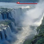
DESCRIPTION: North Park, separated by the Iguazu River forms the international boundary, is his Brazilian counterpart. In 1984 both were declared World Heritage Site by the United Nations. Without doubt the most characteristic birds of the Iguazu Falls are the swifts waterfall, making shows of its accuracy, cross flying the interstices of the water column of the falls, and then landing on the rock wall where they rest and nest.
On the trails it is possible to observe large number and variety of butterflies, in some sectors of the park forest of palm and rosewood develops. The latter is a tree that can exceed 40 meters in height and has a straight trunk up to 2 meters in diameter.
PROTECTED ECOSYSTEM: This National Park was created in 1934 with the aim to preserve one of the greatest natural beauties of Argentina: Iguazu Falls River, next to the generous framework of the subtropical forest that surrounds them.
The Park has seriously threatened animal species like the jaguar, which is in this area one of its last great refuge in Argentine territory. The tree flora of Iguazu National Park has over 90 species. Some of these trees become spectacular when in bloom, as in the case of black lapacho that late winter before its leaves and is covered entirely of pink flowers; yellow lapacho and pytá ibirá, which develop yellow flowers, and wild species of ceibo, with flowers of red-orange color.
ACCESS: The Municipality National Park is located in the town of Puerto Iguazu. In the old Hotel Iguazu is a center reporting, and around there are bars and toilets.
The park has trails, stairs, bridges, walkways and balconies, Adema can be explored on foot much of the Falls area, on trails like the Lower Circuit Upper Circuit, Devil’s Throat: admiring up close the different waterfalls
Alternatively, go to the bird observatory located one kilometer from the Visitor Center, which allows you to admire the inhabitants of the marsh. The Sendero Macuco is one of the traditional outlets for lovers of nature observation. The Path Yacaratiá offers an interesting approach to the forest (to traverse consult reports).

SANTA CRUZ
GLACIER NATIONAL PARK
Southwest of the Province of Santa Cruz.
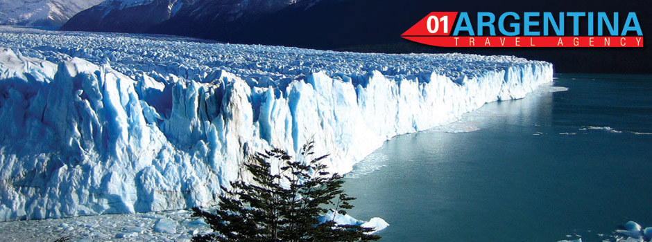
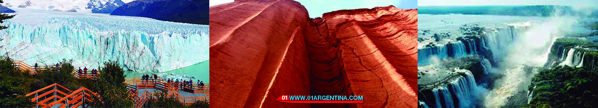
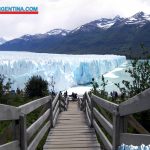
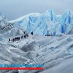
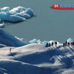
DESCRIPTION: Obviously the most important characteristic appearance in the park are its fields covering 2,600 km2 in its entirety, from which 47 major glaciers descend. The best known is the Perito Moreno glacier, which expands on the waters of the South branch of Lake Argentino, with a front of 5 km and a height, above the lake level of 60 meters. The Upsala glacier, located on the north arm of the same lake, is the largest; It exhibits a length of 50 km and a width of nearly 10 North Park km.Al the grand Fitz Roy massif which has an altitude of 3,375 meters of pure granite, surrounded by the magnificence of the mountain ranges that surround it is.
Protected ecosystem: It was created in 1937 to preserve a vast area of continental ice and glaciers. Due to its spectacular beauty, its glaciological and geomorphological interest, and part of its endangered wildlife, UNESCO declared World Heritage Site in 1981.
Among the fauna, the forest has the presence of huemul. A medium sized deer, which descends during winter tall prairie looking for shelter and food.
Among the birdlife, worth mentioning the black Patagonian carpenter, the austral parrot and hummingbird garnet crown. In aquatic environments is a great diversity of birds, including swans black neck, and as Ruddy ducks and torrents.
To the east, the mountains of the Andes fade in the Patagonian plateau and the forest gives way to steppe. Here guanacos, gray foxes and skunks patagónicos. Among the birds the big brokerage highlighted area.
ACCESS: Access to more convenient National Park is from the north on National Route 3 to Rio Gallegos, continuing along the Provincial Route No.5, National No. 40 and Provincial Route 11 to the town of El Calafate, a distance of 50 km from the park. Between these two cities is a distance of 316 km. From El Calafate up to the town of El Chalten in the northern part of the protected area, linking the Provincial Route 11, National Route 40 and finally Provincial Route 23.Por plane accessed from Buenos Aires to Rio Gallegos, and from there out local flights to El Calafate.
The Municipality National Park is located in El Calafate. In this town and El Chalten, it offers accommodation in inns, lodges and cabins. The camping areas are located in the area of Lake Viedma and Lake Argentino area.
lacustrine excursions Lake Argentino leave from Punta Bandera, allowing to know, among other attractions, Onelli Glacier Bay and Upsalla.
The possibilities of touring the area are diverse, to see the park from different scenarios, such as La Senda to Moreno Glacier, the Path to Base Camp White River, the path to the Laguna and Cerro Torre Base Camp. To perform these activities, it is preferable to consult the parks Guarda.
LA RIOJA
NATIONAL PARK TALAMPAYA
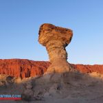
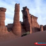
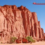
DESCRIPTION: Talampaya comprises a site of worldwide importance for the abundance of fossils. In recent decades they have gained popularity for containing scientific paleontological covering almost the entire Triassic period, when the rise of the dinosaurs.
It also has an important archaeological riches. Human occupations occurred between the years 120 and 1180 AD, used caves and eaves of the place. In the vertical cliffs and large rocks, a large number of figurative and abstract prints express a harmonizing fusion between nature and culture, composing one of the most important locations of the Argentine rock art.
The vegetation is shrubby, sparse and low. The most common fauna is satisfied by gray foxes, the black-footed chuña and calandria mora. The high reddish walls are used as shelter for several birds of prey, such as the Andean condor, the eagle and the peregrine falcon.
Protected ecosystem: In 1975, Talampaya National Park was created in order to preserve an area of 215,000 hectares of forest, home to important paleontological and archaeological sites. Talampaya occupies the low hills, exposing the erosion processes that form in the high canyons, straight walls and encased rivers.
ACCESS: The section of Provincial Route 26 between Villa Union and Los Baldecitos, the latter town on the border of the provinces of La Rioja and San Juan, through the National Park. The reporting center is 14 km of this route, veering to the northeast.
Due to the recent creation of the National Park, it is not yet have the required services for the visitor’s attention. Where the report center is located, it has restrooms and bar, traversed by the Talampaya Canyon where you can see various samples of archaeological heritage, particularly in sectors Talampaya door and drawers are started.