 Church Purmamarca: Data of the year 1648, witnessed his wooden lintel is seen in his front door. Dedicated to Santa Rosa de Lima – was built in 1648. The feast day is celebrated on August 30, features religious ceremonies, sikuris misachicos erques and accompanied by drums. It was declared a National Historic Monument in 1941, simple architecture, adobe walls, roof and mud cake cactus, your sole and narrow nave, images inside and cuzqueñas eighteenth century paintings.
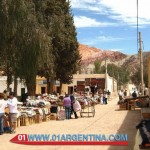
Usefull information for a Tour in Purmamacar Argentina and places to visit.
The Historical Algarrobo: Located next to the Church of excessive trunk and broad crown, was a silent witness to an important part of the history of Jujuy. Under his shadow rested troops Belgrano.
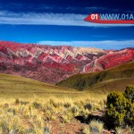
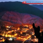
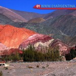
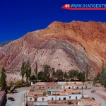
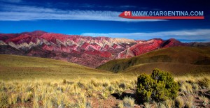
Cerro de Siete Colores: It is unique in the region and the rest of the country. The combination of colors are what make the distinction and delight to the eyes of those watches. It has been proposed as a Natural Monument. Minerals colors correspond to sediments from the Cretaceous Period that culminates 65 million years ago when the dinosaurs disappeared. Also known as Training Yacoraite, the same that are located in Quebrada de las Conchas and Quebrada del Toro.
The town of Purmamarca is at his feet, and they form one of the most recognized post of Northwest Argentina and the country.
The Paseo de los Colorados: Road approximately 3 km, starting from the people that go part of the bed of a tributary of Purmamarca River, overlooking carved by nature on the slopes of the mountains discovering unforgettable landscapes figures.
Cuesta del Lipan circuit winding and steep rising from Purmamarca to Salinas Grandes. Information on the route, its route, attractions and map!
The Cuesta del Lipan is a winding and steep path of National Route 52, located in the department of Tumbaya, Province of Jujuy. The path in the hill has its origin in the town of Purmamarca and reaches its peak (maximum height of the road) in the Abra de Potrerillos to 4170 meters high from where RN52 continues Salinas Grandes to Paso de Jama .
The hill has a fully paved road that goes winding in its ascent. A few hundred meters before reaching its peak there is a viewpoint from where you can see the precipitous slope in most of its length.
Of approximately 17 kilometers, the slope rises from the limits of the town of Purmamarca, at 2,192 m to 4,170 m in the Abra de Potrerillos, through the Cerro de los Siete Colores in an ascent from east to west toward the Puna de Atacama. Then down to the Salinas Grandes to 3,450 meters.
Note that La Cuesta de Lipan received the 2004 Road Work Award for the Argentina Road Association, which brings together all the provinces, industry peers and the national government.
El quemado: The Burn glaciers are solid ice formation, caused by a natural spring height, which, because of the low temperatures, solidifies up to approximately one meter thick. This phenomenon occurs between the months of May and August. They are located 33 km. Purmamarca, on National Route No. 52-3980 meters, before reaching the highest point on roads in the province of Jujuy.
Salinas Grandes: Salinas have silence, the pleasure of pure air, sea salt to 525 km2, make them a part of remarkable natural beauty.
From the National Route 52 and 3,600 meters, its outline is highlighted on the horizon many miles away. Who wants to get to the salt primarily ecstasy over the sea salt, I just look at it. A beauty salar blue skies and a very special light come together.
One of the greatest depressions in the province of Jujuy. There the silence is only broken by the steps themselves to a dry surface, and the predominant feeling is inexhaustible and incomprehensible vastness of the senses.
Unforgettable trip passage through these lands, the Salinas Grandes are unveiled by local workers, who dazzled visitors explained the whole process of extraction of salt and make small sculptures saline given away as a souvenir.
A 126 Miles of Purmamarca, after climbing the hill to the Abra de Lipan Potrerillos, this sea salt captive eyes and thought.
It is advisable to visit the place in the morning.
Purmamarca – Huachichocana: Where the first men to walk the Gorge lived 10,000 years ago.
It was also a strategic point for barter in the past. In it the residents of the Puna and the lowlands to exchange their products were.
Location: From the bridge Huacha on National Route 52, 4 miles. south, on the left bank, in a way inaccessible to vehicles. It is advisable to make your visit with experienced and licensed guides.
Hornocal mountain range is an impressive ultra wide spread formation but polychromatic, located 25 kilometers from the town of Humahuaca, Jujuy. Unique in its size, number of colors and odd shapes of peaks and “U”.
The mountain range is a mountain Hornocal located 25 kilometers from the town of Humahuaca, Jujuy is an ultra polychromatic, training widely disseminated as it jealously guards the area of impact of tourism exploitation. It is part of the limestone formation called Yacoraite extending from Peru to Salta, through Bolivia and the Quebrada de Humahuaca. It is amazing the variety of colors-there are those who see up to 33 tonalidades-. It has a height of 4761 meters above the sea.
It can be visited the whole year and is recommended to visit this site in the afternoon, when the sun gives head and intensifies color shades. The imposing rock mass of thousands of colors called foothills of Hornocal allows sensations. It is a unique training in their size, number of colors and odd shapes of peaks and “U”. are famous postcards of Mount Seven Colours Purmamarca and Painter’s Palette in Maimará, but most of the tourists go Humahuaca without knowing this particular and shocking sight.
Getting there
Too you can buy a Tour to Purmamarca in our luxury travel tours website.
From Humahuaca are only 24.5 miles and about 40 minutes drive to the viewpoint facing the hill. They are passable in ordinary car for rubble, although it is recommended not to venture into summer without checking for possible cuts from the rain. Two blocks north of the bus station of the town of Humahuaca the only bridge over the Rio Grande crosses. To the left is then taken on provincial route 73, which goes to Santa Ana. Always Stay on the main road and not take detours to Coctaca or to Ocumazo. A winding hill leads to Abra Aparzo where three roads meet. The least important is to be taken: do well on the right path and maintenance of antennas, which comes after 1.7 km Lookout Hornocal.