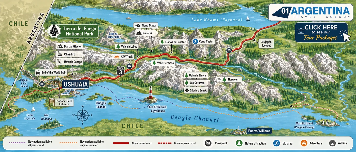
Ushuaia is easier to understand than it looks, because the whole place is organised around one road. Route 3 runs east to west through the city, the mountains rise behind it, the Beagle Channel lies in front of it, and virtually every excursion sold here is either a short way west of town, a short way east of it, or out on the water. Once you see that, an itinerary stops being a guessing game. The map is ours. The distances underneath it are the part a drawing cannot tell you.
The legend along the bottom of the drawing, written out — because the difference between the two dotted lines is the difference between a boat that sails in August and one that does not.
The short Beagle Channel run. It goes as far east as the Les Éclaireurs lighthouse and the Bridges Islands and comes back. It sails in July and August too.
The long run east to Martillo Island and the penguin colony, and the crossing to Puerto Almanza. Roughly November to early April.
Route 3. West of the city it ends inside the national park; east of it, it climbs into the mountain valley and carries on north towards Lake Khami and Río Grande.
Provincial Route J, the branch that leaves Route 3 and drops down to the far eastern shore of the channel at Puerto Almanza and Harberton.
Places worth stopping the vehicle for. The Martial ridge above the city and the lookout over Lake Khami are the two most photographed.
Valleys, lakes, lenga forest and peat bog — most of what is marked east of the city sits in one long glacial valley.
The winter centres, all of them on Route 3 east of Ushuaia. Cerro Castor is the alpine resort; the rest of the valley is cross-country, sledding and snowmobiles.
Off-road tracks and canopy, mostly in the same eastern valley.
Penguins on Martillo Island, sea lions and cormorants on the islets off the port, and the husky kennels in the winter valley.
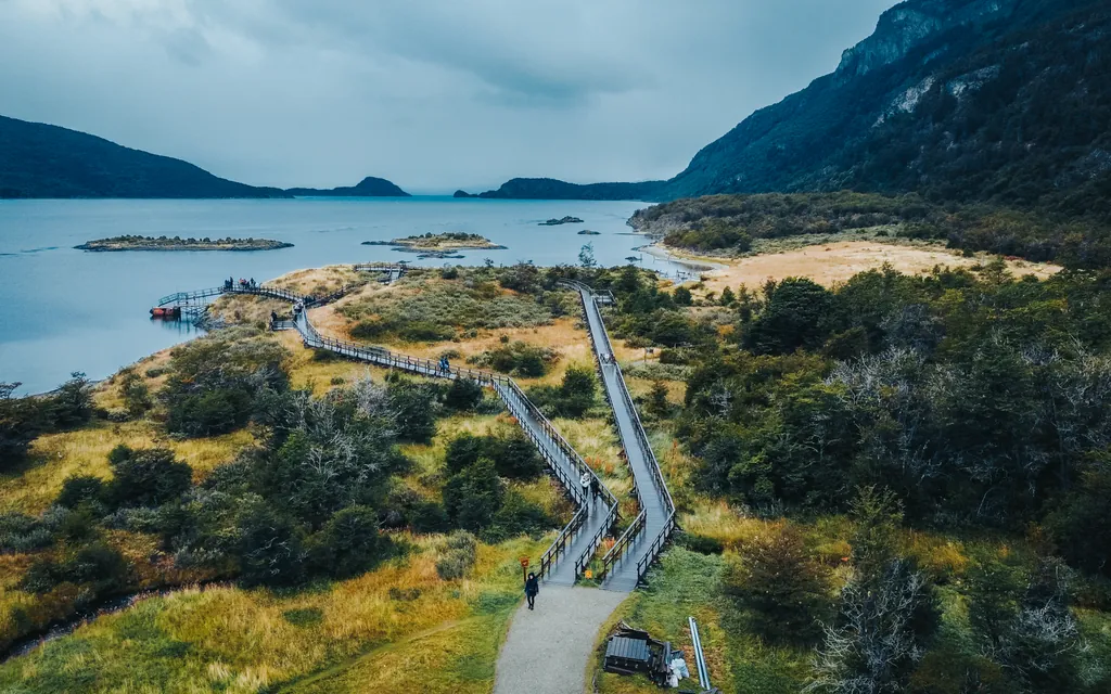
Drive west out of Ushuaia and within twelve kilometres you are at the gate of Tierra del Fuego National Park. This is the green wedge on the left of the map, and it is where the forest comes all the way down to the water.
Keep going and the road runs out. At about twenty kilometres from town you reach Bahía Lapataia, where Route 3 simply stops at a wooden sign. That sign is the thing everyone photographs. It reads Buenos Aires 3,079 km and, underneath, Alaska 17,968 km — which is a fair summary of where you are standing.
Inside the park, on the map, you can see Lago Roca sitting hard against the Chilean border, and Isla Redonda out in the bay. The map labels the lake Acigami, its Yámana name, which was the official one between 2008 and 2024 before the national parks administration restored Roca; both names are in common use locally. The river that drains it into Bahía Lapataia runs through this western corner of the park.
The End of the World Train boards just before the park entrance. It was built by the convicts of the old Ushuaia prison to haul timber, and today it is the southernmost working railway on the planet.
Head the other way and Route 3 climbs behind the city into a wide glacial valley. Everything marked on the right-hand side of the map lives in it: the cross-country and sledding centres, the husky kennels, the off-road tracks, the trailhead for Laguna Esmeralda, and at 26 kilometres, Cerro Castor — the southernmost alpine ski resort in the world.
This is the half of Ushuaia most summer visitors never see, and it is a mistake. In winter it is the entire product. In summer the same valley is a peat bog full of beaver dams, and it is where the road portion of the long Puerto Almanza excursion goes.
Carry on north and the road crosses the Fuegian Andes at Paso Garibaldi, about 450 metres above sea level, with the lookout over the lake below it. Beyond that is Lake Khami — the Selk’nam name for what the maps mostly call Lago Fagnano — roughly a hundred kilometres from Ushuaia by road, so long that its far end crosses into Chile. The smaller lake at the foot of the pass is a different one, and much closer.
Further east again, a gravel branch leaves Route 3 and drops back down to the water. That is Route J, and it leads to Puerto Almanza at 75 kilometres and the historic estancia at 82. Off that coast lies Martillo Island, about 90 kilometres from Ushuaia, where the penguins are.
In front of Ushuaia is the Beagle Channel, named after the ship that carried Darwin through it in the 1830s. It is not a river and not open sea: it is a strait a few kilometres wide in front of the city — narrower in places, much wider in others — running east to west between the mountains.
The first thing any boat passes is the cluster of islets off the port — sea lions on the rocks, cormorants above them — and then Les Éclaireurs lighthouse, the red and white tower that half the postcards of Ushuaia are of. It is often called ‘the lighthouse at the end of the world’, which is good marketing and not quite true; that title belongs to a different lighthouse further east, on Isla de los Estados.
The Bridges Islands are just beyond it. They are the only place on the whole channel where a standard excursion actually puts you ashore on foot.
And the far shore, the one with the town on it, is Chile. That settlement on the map is Puerto Williams, on Isla Navarino, and it is the reason the Beagle Channel is a border as well as a waterway.
A map shows you a shape. This shows you the numbers. Distances are by road from the centre of Ushuaia unless stated otherwise.
| Place | From Ushuaia | Direction | What it is |
|---|---|---|---|
| Martial ridge and chairlift | 7 km | Directly above the city | A viewpoint over the whole channel, reached by a chairlift from the valley floor. |
| Tierra del Fuego National Park entrance | 12 km | West on Route 3 | The park gate. The End of the World Train boards just before it. |
| Bahía Lapataia | About 20 km | West, end of Route 3 | Where the road stops. The sign reads Buenos Aires 3,079 km, Alaska 17,968 km. |
| Lago Roca (Acigami on the map) | — | West, inside the park | Pressed against the Chilean border. Drains south into Bahía Lapataia. |
| The winter valley | — | East on Route 3, before Cerro Castor | One long glacial valley holding the cross-country centres, husky kennels, off-road tracks and the Laguna Esmeralda trailhead. |
| Cerro Castor | 26 km | East on Route 3 | The southernmost alpine ski resort in the world. Season roughly mid-June to early October. |
| Paso Garibaldi | — | Northeast on Route 3 | Where Route 3 crosses the Fuegian Andes, about 450 m above sea level, with the lookout below it. |
| Lake Khami (Lago Fagnano) | About 100 km | Northeast, over the pass | Long enough to reach into Chile. Khami is its Selk’nam name. Not to be confused with the much closer small lake below Paso Garibaldi. |
| Puerto Almanza | 75 km | East, Route 3 then Route J | A fishing village on the far eastern shore of the channel. The last stretch is gravel. |
| The historic estancia | 82 km | East on Route J | On the shore of the channel, near the eastern end of Route J. |
| Martillo Island | About 90 km | East, offshore | The penguin colony. Magellanic penguins and a small number of gentoos breed here roughly from October to April; the navigations that go out to it run from about November. |
| Les Éclaireurs lighthouse | — | In the channel, east of the port | The first landmark on every navigation, whatever its length. |
| Bridges Islands | — | In the channel, near the city | The only landing on foot on any standard Beagle Channel excursion. |
| Puerto Williams, Chile | — | Across the channel, south | On Isla Navarino. The channel is an international border along its whole length here. |
| Buenos Aires | About 3,000 km | North | A flight of roughly three and a half hours. There is no practical way to drive it in a holiday. |
The two dotted lines heading east from the port are not decoration. They are the reason travellers get confused about which boat to book, and the map settles it: all three leave the same pier — what changes is how far east they go.
The short purple line. Sea lions, cormorants, Les Éclaireurs, and a twenty-minute walk ashore on one of the Bridges Islands. It is the only one that runs every month of the year, including July and August.
More ›The orange line, carrying on east past the point where the short trip turns around, as far as the penguin colony — watched from the boat. Roughly 1 November to early April, because the penguins are only there to breed.
More ›The one that does not return the way it came. Out by catamaran past the colony, ashore on the far side for lunch, the southernmost farm in the world, and then home overland on Route J and Route 3 through the beaver valley. It is the only excursion that closes the loop you can see on the map.
More ›A map is honest about distance and silent about everything else, and down here everything else is usually what decides the day. Ninety kilometres to the penguin colony sounds like nothing. It is nothing — on a calm morning. On a windy one the boats do not sail at all, and that is not a rare event: it is a normal part of a week in the Beagle Channel.
The second thing the drawing hides is the season, which changes the map more than the map changes. The two dotted lines running east are the clue. One of them operates every month of the year; the other only exists between roughly November and early April, because the animals it goes to look at are only there to breed. Arriving in August expecting penguins is a disappointment we have watched happen more than once, and a single conversation beforehand prevents it entirely.
The third is the light. At almost fifty-five degrees south the length of the day swings violently. In late December the sun is still up past ten at night, which means an excursion finishing at nine-thirty finishes in daylight and a full day genuinely holds two activities. In late June you have somewhere around seven hours of it, and the same map has to be read completely differently.
And the fourth is that the two halves of Ushuaia — the park in the west, the valley in the east — do not want the same weather or the same clothes, and the excursions that go to them are sold by different operators with different departure points and different cancellation habits. Holding those pieces together across three or four days, and reshuffling them when a Tuesday is lost to wind, is not something a map does. It is the reason a local agency exists.
Free written quotation within 24 hours, with no obligation. Send us when you are travelling, how many of you there are and how long you have — we will come back with an itinerary that accounts for the weather, the season and the fact that half of what you want to see is on the opposite side of town from the other half.
The map answers where. These answer which one, how long and how much.
Flights, hotels, transfers and excursions quoted as one price, built around your dates.
See the packages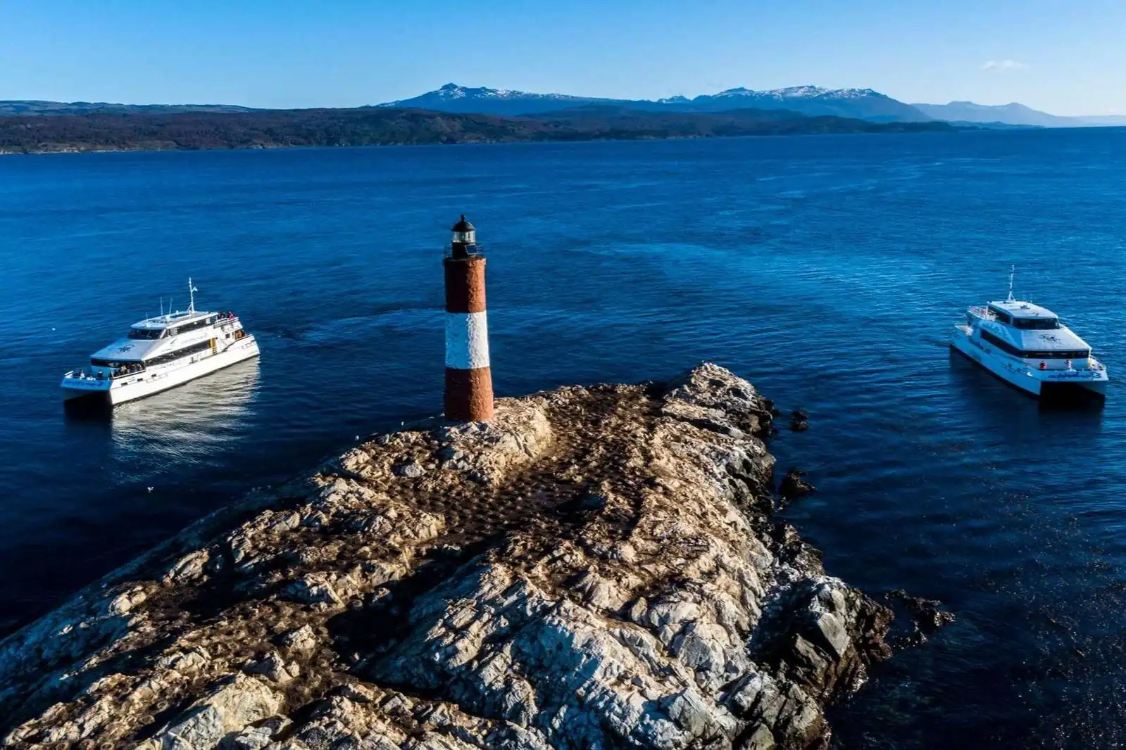
Every excursion we operate in Ushuaia, compared against each other so you do not book the same coastline twice.
Compare them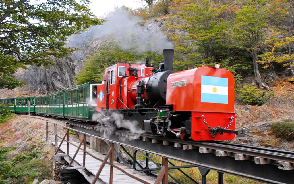
An honest answer from an agency that has been arranging these trips for twenty years.
Read the article