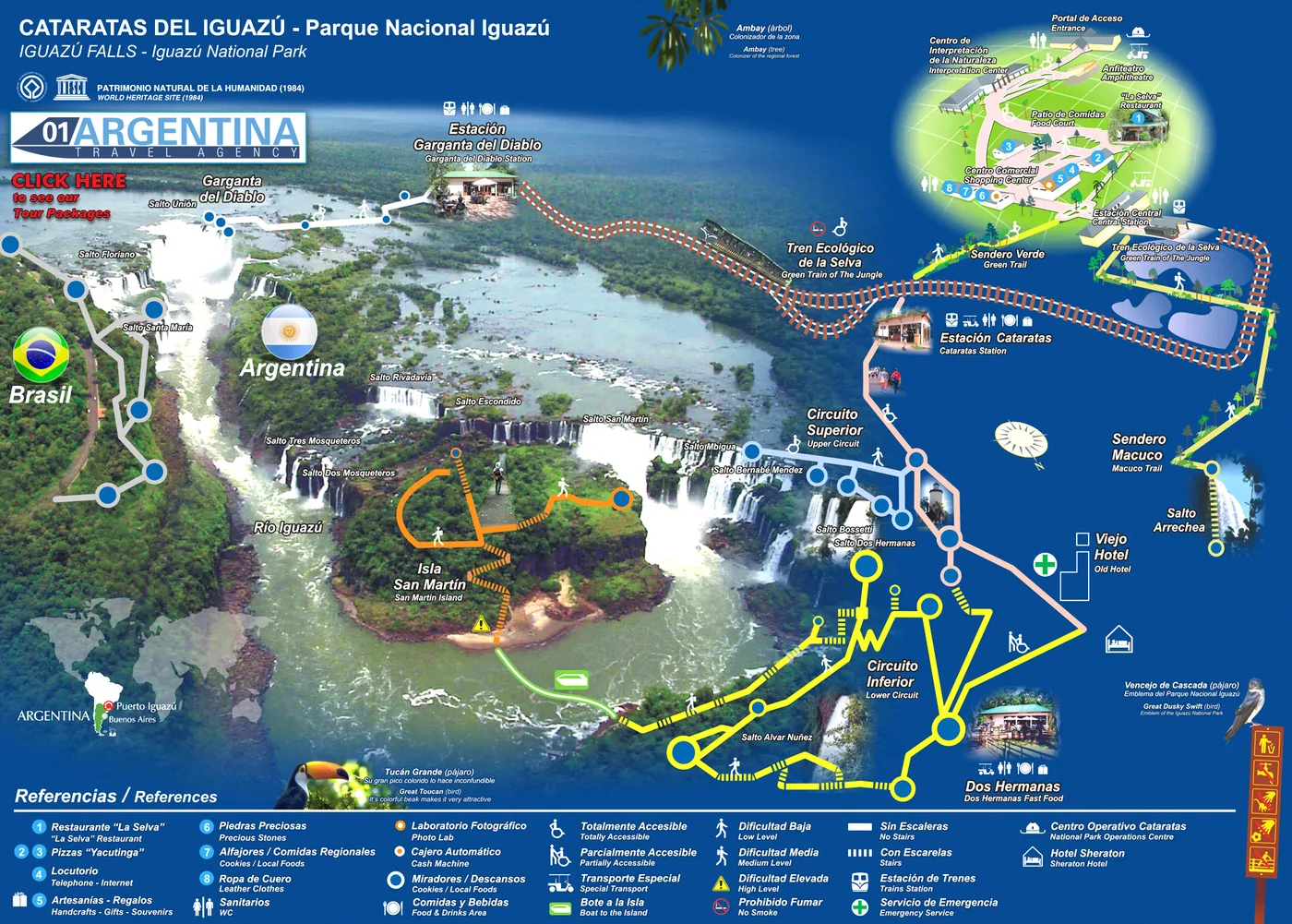
Iguazú is not one waterfall. It is 275 of them, spread along almost three kilometres of river, on a border. Roughly four fifths sit on the Argentine side, where you walk out among them on steel walkways; the rest sit on the Brazilian side, which is where you stand back and see the whole thing at once. That is the single most useful fact about visiting, and it is why the map matters more here than almost anywhere else. Below it, every circuit with its real length and walking time.
The green half of the map, on the right, is Argentina. This is where the walkways are, and it is why most people give the Argentine side a full day and the Brazilian side half of one. You are not looking at the falls from a distance here — you are standing over them, under them, and in the spray.
Three circuits do the work. The Upper Circuit runs 1,850 metres along the top of the escarpment, looking down the throat of each fall as it goes over; it is flat, fully accessible, and takes about two hours if you stop to look. The Lower Circuit is 1,750 metres and goes the other way — down to the base, where you get wet.
The Devil’s Throat is separate, and it is the one people come for. From the far station a walkway of about 1,100 metres crosses the upper river to a platform at the lip of a fall 150 metres wide with a drop of more than eighty. The full circuit, there and back, is 2,200 metres.
Two more marked on the map are worth knowing about. Sendero Verde is a short 650-metre link, fully accessible, that connects the visitor centre to the circuits. And Sendero Macuco is a proper 3,500-metre jungle trail through the forest to a hidden fall, allow three hours, and it is the only part of the day where you are likely to be alone.
The left of the map is Brazil, and the relationship between the two sides is simple: Argentina puts you inside the falls, Brazil lets you see them. The Brazilian park has far fewer of the 275 falls but it faces the Argentine escarpment head on, so from its walkway you get the panorama that ends up being the photograph.
The two are different countries and different parks, with separate entrances, separate tickets and a border crossing between them. They were recognised separately too: the Argentine park was made a UNESCO World Heritage site in 1984 and the Brazilian one in 1986, which together protect the whole falls system and the Atlantic forest around it.
Whether you need both is the question we get most, and the honest answer is that it depends on how many days you have rather than on the falls. If you have two full days, do both and you will be glad. If you have one, do Argentina.
The Argentine park is large and the distances on the map are real, so a narrow-gauge train runs through it. The Ecological Jungle Train has three stations: Central, near the entrance; Cataratas, where the Upper and Lower Circuits begin; and Garganta del Diablo, where the Devil’s Throat walkway starts.
You can walk between the first two on the Sendero Verde. You cannot realistically walk to the third — that is what the train is for, and it is the reason the Devil’s Throat is usually done either first thing or last, depending on how the queues are running that day.
Everything on this map sits 18 kilometres from Puerto Iguazú, the town, which is about half an hour by road. The town has its own map, with the hotel zone and the airport on it, and that is a different question — the one about where to sleep rather than what to see.
A map shows you shape. This shows you distance, time and whether you can get a wheelchair round it. All of it on the Argentine side unless stated.
| Circuit or trail | Length | Time | Accessible? | What it is |
|---|---|---|---|---|
| Upper Circuit | 1,850 m | About 2 hours | Fully accessible | Along the top of the escarpment, looking down each fall as it goes over. Flat the whole way. |
| Lower Circuit | 1,750 m | About 1½ hours | Partly accessible | Down to the base of the falls. Stairs in places, and you will get wet. |
| Devil’s Throat circuit | 2,200 m there and back | About 1½ hours | Accessible walkway | 1,100 m of walkway across the upper river to the lip of a fall 150 m wide and over 80 m deep. Reached by train. |
| Sendero Verde | 650 m | About 15 minutes | Fully accessible | The short link between the visitor centre and the start of the circuits. |
| Sendero Macuco | 3,500 m | About 3 hours | Not accessible | A real jungle trail through the forest to a hidden fall. The quiet part of the park. |
| San Martín Island | — | Allow an hour | Not accessible | An island in front of the falls, reached by a short boat from the Lower Circuit. Steep steps, and it only runs when the river allows. |
| Ecological Jungle Train | 3 stations | — | Accessible | Central, Cataratas and Garganta del Diablo. The only sensible way to reach the Devil’s Throat. |
| Brazilian side walkway | — | Half a day | Largely accessible | Across the border. Faces the Argentine escarpment, so this is where the panoramic view is. |
| Puerto Iguazú to the park | 18 km | About 30 minutes | — | By road. The town is where the hotels, the airport and the three-border landmark are. |
The first thing missing is the noise. You hear the Devil’s Throat several minutes before you reach it, as a low sound you feel through the walkway rather than hear, and it makes conversation on the platform impossible. Nobody is prepared for it and everybody remembers it.
The second is the water level, which changes what you get more than the season does. After heavy rain upriver the falls are brown, enormous and half hidden in their own spray; in a dry spell they separate into individual ribbons of clear water and you can see the rock behind them. Both are worth seeing and they look like different places. This is also why sections of the park close at short notice, and why the boat to San Martín Island does not always run.
The third is timing inside the day. The map makes the park look like a loop you walk once, but it is really a question of where the crowds are at eleven in the morning. Going straight to the Devil’s Throat on arrival, or leaving it until late, changes the day completely — and which of the two works depends on the month, the coach arrivals and how the train is running.
And the fourth is that this is a border. The two parks are two countries with two entrances, two tickets and a crossing in between. Fitting both into an itinerary that also has flights in it is not hard, but it is the sort of thing that goes wrong quietly — and unpicking it from three thousand kilometres away, on the day, is the part we get paid for.
Free written quotation within 24 hours, with no obligation. Send us when you are travelling and how long you have at the falls — we will tell you honestly whether you need one day or two, whether the Brazilian side is worth it for your route, and what the river is doing.
The map answers where. These answer which tour, how many days and where to sleep.
Every package and excursion we run at the falls, from two nights to the full route with Buenos Aires.
See the packages
Straight answers to what people actually ask before booking — tickets, days, seasons and the border crossing.
Read the answers
The other map: where the hotels, the centre, the airport and the three-border landmark actually are.
See the town map